
Namaste. The Annapurna region of the Himalayas is home to two or three of the world’s ten tallest mountains. The Annapurna Circuit is a 100-200 mile trek around the entire mountain range. Annapurna Base Camp is a much shorter trek into the heart of the mountains. I decided to do both. Plus a few side trips. (I also visited a different area of Nepal this spring.) I would suggest that you visit the various page in the following order (more or less, as fits your mood):
- Scenic photos: My favorite aspect to the trip
- Annapurna Circuit from low to high: From the low elevation start at Besisahar to the epic high point at Thorung La. Please use the biggest screen you have to view these photos. (Yes, I know there are too many of them.)
- Annapurna Circuit from high to low: From Thorung La to the ending at Ghorepani
- Annapurna Base Camp: From Ghorepani to ABC to Phedi
- Life: Some scenes of ordinary life in Nepal
- Religion: It was impossible to go far without seeing the influence of religion
- Miscellaneous: Photos that don’t fit anywhere else
- Place names: One of the joys of this trip was the place names, which always seemed to put a smile on my face
- Fun stuff: The less serious side of my trip
- Oddities: Westerners might like these photos
If you’re short on time, try these:
- My 10 favorites: Which is your favorite child? This was a terrible effort. Here, I show my more or less favorite photos. Hint: They’re all scenics.
- Quick Intro: A little bit of everything in this region in 25 photos (from my limited experience)
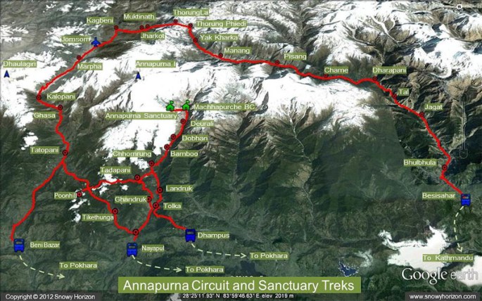
Above is a map of the Annapurna region. My trek proceeded as follows:
- Start in the east at Besisahar
- Trek to Manang
- Trek west to Tilicho Lake and then back to Manang. Unfortunately, this map does not show Tilicho Lake; it is a little north of “Annapurna I.”
- Trek over Thorung La, which is the high point of the trek at 17,769 ft.
- Trek to Tatopani and then Ghorepani, which is next to Poonhill.
- Trek through Chhromrung to Annapurna Sanctuary (aka Annapurna Base Camp)
- Trek back through Dhampus to Phedi
Total trip statistics: 25 days, approximately 260 miles (including side trips)
